Online Data Proc and Acqui SIG: A Model for Fluvial Sand Channel System Reservoir Delineation and ...- May 5th

Complete Title: A Model for Fluvial Sand Channel System Reservoir Delineation and Optimal Drill Location Selection Utilizing Post Stack Processing, Precise Amplitude Attribute Analysis and Stratal Domain Visualization and Interpretation Sponsored by Schlumberger
Online Presentation
You MUST pre-register to receive a link to the presentation.
NOTE: You Must be Logged in to Register
Speaker: Coerte Voorhies, III, P.G., Gustavson Associates, LLC
A model was created utilizing InsightEarth software technical analysis to lower risk associated with selecting well locations for optimal reservoir stratigraphic, structural and production constraints. The software provides for volume processing, accurate attribute analysis and 3D stratal domain volume visualization and interpretation. Advanced algorithms identify subtle structural and stratigraphic edges in SGY seismic amplitude data.
Technical results were used to delineate and create maps for a productive fluvial sand channel system in the Client’s project area in Kazahstan that is analogous to fluvial systems in Colorado and Wyoming basins. Project data was provided by Gustavson Associates, LLC of Boulder, CO and consists of a 350 square kilometer 3D seismic volume. The project’s production is from an intricate fluvial sand system where the numerous channels as originally interpreted concealed the continuity of the reservoir and contributed to the drilling of several non-productive wells.
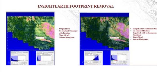
Acquisition footprint and random noise were eliminated from original data to condition the seismic volume. Accurate dip-guided amplitude attributes were generated from the conditioned volume. The stratal domain transform process was used to convert the conditioned time and attribute volumes into paleo-surface stratal volumes. The objective was to obtain an accurate structural and stratigraphic interpretation of a productive sand. The stratal slice volume is a structural accuracy test. Resulting horizontal events indicated a correct structure and non-horizontal events indicated an inaccurate structure interpretation. Structural relationships were corrected in the time domain volume and the new stratal domain volume yielded horizontal events (stratal slices) that imaged the intricate fluvial systems to represent the depositional environment of the reservoir.
Stratal domain volume results and structural analysis indicate that the reservoir and associated complex faulted structure of a previously selected well location were not ideal. Precise attributes calculated from advanced algorithms show the reservoir morphology and instantaneous amplitude attribute anomalies targeted in the Client’s drilling program. The new reservoir interpretation provided the required risk analysis to recommend the selection of an alternate well location.
By utilizing volume conditioning (acquisition footprint removal), attribute analysis and stratal domain visualization and interpretation, a model was created to accurately map the recognizable morphologies of fluvial sand channel systems to provide precise reservoir delineation and optimal well location selection for the Client’s project and project development in analogous geographic locations.
 Speaker Biography: Coerte A. Voorhies, III, M..S., P.G., Gustavson Associates LLC
Coerte is a geophysical and geological interpreter with over thirty years of international and domestic experience. Coerte is an expert user of the CGG InsightEarth® 3D Visualization, Processing and Interpretation Software Technology (CGG: InsightEarth) and is currently providing InsightEarth® consulting services for Gustavson Associates, Boulder CO (Gustavson – Oil Gas and Mining Consultants Colorado USA) . He has developed and managed geophysical and geological projects in the Permian Basin, Gulf Coast Basin, Colombia Llanos Basin, South China Sea Basin and the West Africa Offshore Gabon Basin. Coerte has served in various capacities as manager, technical expert and consultant to ExxonMobil, ChevronTexaco, BHP, Santa Fe Minerals, Delta U.S. Corporation and others. He holds a Bachelor of Science (B.S.) and a Master of Science (M.S.) in Geology from the University of Louisiana - Lafayette and a SIPES member, GSH Member and is a professional geoscientist in Texas.
Time Schedule:
5:00 PM – start of presentation
6:00 PM - close of meeting
THANK YOU TO OUR GENEROUS SPONSOR: